


New York, Dallas, Seattle and 25 other major U.S. cities are sinking, threatening the structural integrity of buildings, roads, dams and other forms of infrastructure, new research found. The study's authors say it represents a looming threat to the infrastructure of these cities, which combined are home to some 34 million people.
The study by Virginia Tech researchers, published in the journal Nature Cities on Thursday, used satellite-based radar measurements to visualize movement of the land underneath the nation's most populated cities, which they say is largely due to groundwater extraction.
In all 28 of the cities they analyzed, at least 20% of urban areas are sinking, the researchers said. In 25 of the cities, they found at least 65% of the area is sinking, and more than 29,000 buildings are located in "high and very high damage risk areas, indicating a greater likelihood of infrastructure damage."
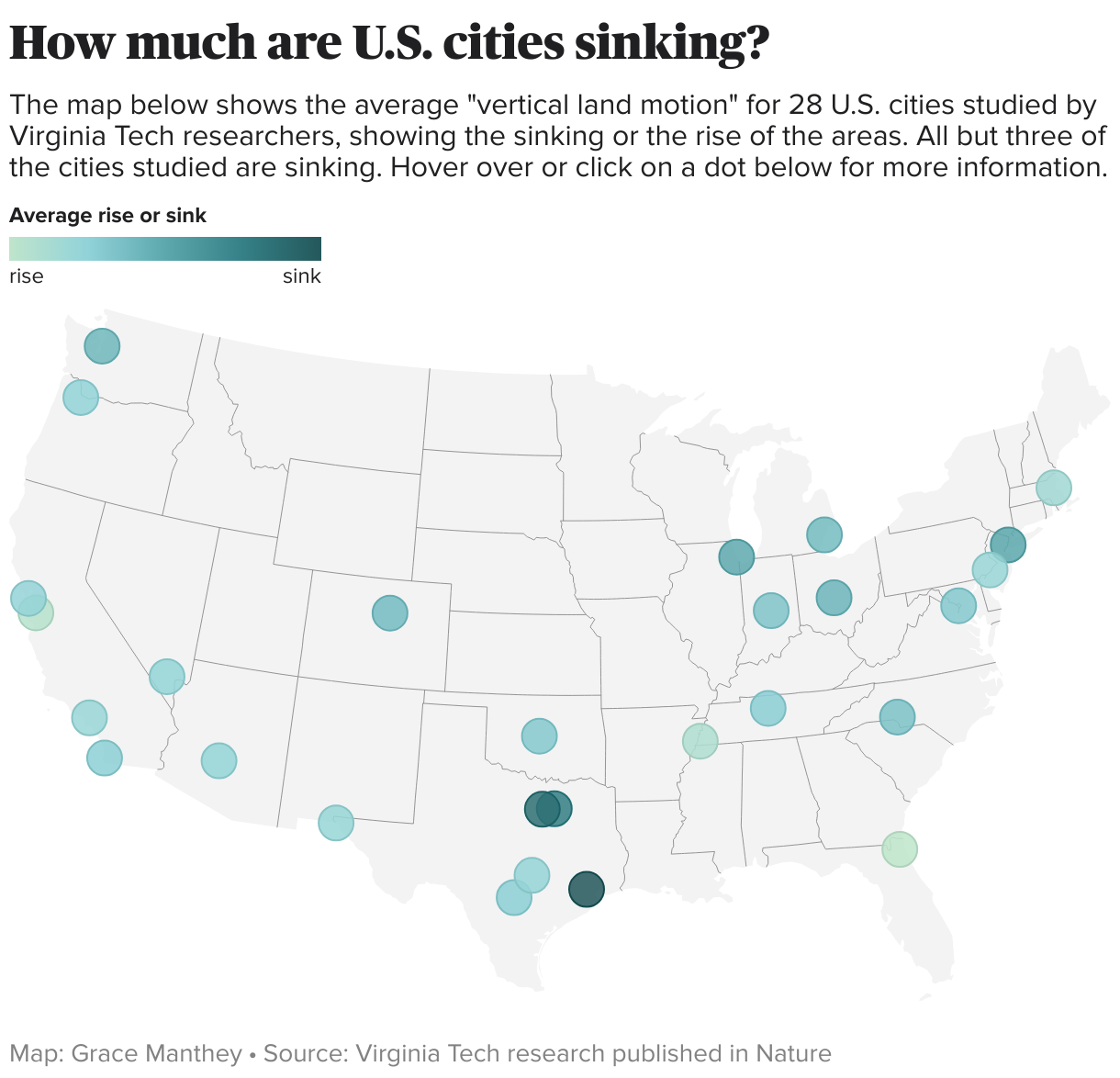
The cities with the most widespread sinking — impacting about 98% of their individual areas — are Chicago, Dallas, Columbus, Detroit, Fort Worth, Denver, New York, Indianapolis, Houston and Charlotte.
Leonard Ohenhen, lead author of the study, said in a press release that when land shifts downward, even slightly, it can significantly compromise the structural integrity of buildings, roads, bridges and dams.
"A lot of small changes will build up over time, magnifying weak spots with urban systems and heighten flood risks," Ohenhen said.
Manoochehr Shirzaei, an associate professor who works at Virginia Tech's Earth Observation and Innovation Lab, explained that the "infrastructure can be silently compromised over time, with damage only becoming evident when it is severe or potentially catastrophic."
"This risk is often exacerbated in rapidly expanding urban centers," Shirzaei said.
A major reason for this is groundwater extraction, they found, as rapidly growing cities demand more freshwater that must be drawn from aquifers. If that water is taken out faster than it can be replenished, the aquifer can crumble.
Further compromising cities' structural integrity is the damage from extreme weather, amplified by climate change, which wasn't included in the study but nonetheless poses a threat. Experts have previously told CBS News that U.S. roads are not built to withstand rising global temperatures and excessive precipitation, which can cause them to buckle and collapse. The early April storms in the Midwest and South that killed at least two dozen people and caused widespread damage were made 14 times more likely due to higher temperatures in the Gulf of Mexico, according to another study published this week.
Repeated events such as these can degrade building materials and damage structures, further exacerbating the toll of the weakening ground below.
Shel Winkley, a weather and climate engagement specialist with Climate Central and author of the April storms study, said their research shows "It's really a moment for us to understand what this means not only now but for the future."
Here are the cities analyzed in the study.
Houston, Fort Worth and DallasResearchers found that several cities in Texas, which they noted as the fastest-growing state, "exhibit the highest measured subsidence rates among all cities," with an average sinking rate exceeding 4 millimeters every year.
Houston was the fastest-sinking city out of those studied, with 42% of its land area subsiding faster than 5 mm per year and 12% subsiding faster than 10 mm per year, researchers found.
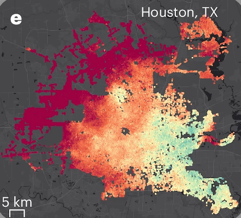 Spatially varying vertical land motion for Houston, Texas. Yellow-orange-red hues indicate elevation loss, while green-purple-blue areas show an elevation gain.
Ohenhen, L.O., Zhai, G., Lucy, J. et al. Land subsidence risk to infrastructure in US metropolises. Nat Cities (2025). https://doi.org/10.1038/s44284-025-00240-y
Spatially varying vertical land motion for Houston, Texas. Yellow-orange-red hues indicate elevation loss, while green-purple-blue areas show an elevation gain.
Ohenhen, L.O., Zhai, G., Lucy, J. et al. Land subsidence risk to infrastructure in US metropolises. Nat Cities (2025). https://doi.org/10.1038/s44284-025-00240-y
However, the study says, "it is essential to highlight that vertical land deformation often varies spatially within cities," and noted that some cities can experience "hotspots" with otherwise overall average land movement.
"From an urban risk perspective, the cities with the greatest spatial variability may experience the greatest hazard to urban infrastructure," the study says.
New York City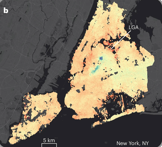 Spatially varying vertical land motion for New York City. Yellow-orange-red hues indicate elevation loss, while green-purple-blue areas show an elevation gain.
Ohenhen, L.O., Zhai, G., Lucy, J. et al. Land subsidence risk to infrastructure in US metropolises. Nat Cities (2025). https://doi.org/10.1038/s44284-025-00240-y
Spatially varying vertical land motion for New York City. Yellow-orange-red hues indicate elevation loss, while green-purple-blue areas show an elevation gain.
Ohenhen, L.O., Zhai, G., Lucy, J. et al. Land subsidence risk to infrastructure in US metropolises. Nat Cities (2025). https://doi.org/10.1038/s44284-025-00240-y
At least 10% of New York City is sinking, researchers found, but greater subsidence of more than 5mm per year has been found in LaGuardia Airport, one of the city's three major airports. LaGuardia recently underwent an $8 billion renovation and was named the best airport in the U.S. by Forbes Travel Guide in 2024.
"New York City alone accounts for 26% of the total subsiding population," the study says, "with the other seven cities making up 5-8% of the population residing on subsiding land."
San Francisco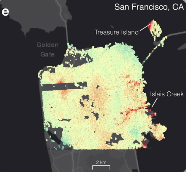 The spatially varying vertical land motion (VLM) for San Francisco, where yellow-organge-red hues indicate elevation loss (land subsidence) and green hues indicate elevation gain (uplift).
Ohenhen, L.O., Zhai, G., Lucy, J. et al. Land subsidence risk to infrastructure in US metropolises. Nat Cities (2025). https://doi.org/10.1038/s44284-025-00240-y
The spatially varying vertical land motion (VLM) for San Francisco, where yellow-organge-red hues indicate elevation loss (land subsidence) and green hues indicate elevation gain (uplift).
Ohenhen, L.O., Zhai, G., Lucy, J. et al. Land subsidence risk to infrastructure in US metropolises. Nat Cities (2025). https://doi.org/10.1038/s44284-025-00240-y
On the West Coast, vertical land motion — a term for how much the ground is sinking — may be at least partially influenced by tectonic activities, researchers found. Like other coastal cities included in the study, such as Los Angeles, San Diego and Jacksonville, San Francisco is also impacted by sea level rise. Much of the city was found to have at least a medium risk to its infrastructure damage due to sinking.
"Whereas natural processes influence urban land subsidence in the United States, most of the sinking land results from human-driven activities, with 80% of the subsidence associated with groundwater withdrawals.
ChicagoChicago has an area-weighted vertical land movement of more than 2 millimeters per year, the researchers found. At least 10% of the city's area is sinking at a rate exceeding 3 mm per year.
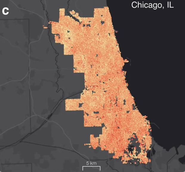 Map shows vertical land motion (LVM) for Chicago, with yellow-orange-red hues indicating elevation loss.
Ohenhen, L.O., Zhai, G., Lucy, J. et al. Land subsidence risk to infrastructure in US metropolises. Nat Cities (2025). https://doi.org/10.1038/s44284-025-00240-y
Other major cities
Map shows vertical land motion (LVM) for Chicago, with yellow-orange-red hues indicating elevation loss.
Ohenhen, L.O., Zhai, G., Lucy, J. et al. Land subsidence risk to infrastructure in US metropolises. Nat Cities (2025). https://doi.org/10.1038/s44284-025-00240-y
Other major citiesCities that are sinking between 1 and 2 millimeters every year include: Columbus, Ohio; Seattle; Detroit; Denver; Charlotte, North Carolina; Oklahoma City; Indianpolis; Washington, D.C., San Antonio, Texas; San Diego; Nashville, Tennessee; Los Angeles; and Las Vegas.
Cities that are sinking at less than 1 mm per year, based on area-weighted vertical land movement, include: Portland, Oregon; Phoenix, Arizona; El Paso, Texas; Austin, Texas; Philadelphia and Boston.
Three other cities — Memphis, Tennessee; San Jose, California; and Jacksonville, Florida — had a slightly positive vertical land movement, indicating a gain in elevation, the researchers found.
ClimateWatch: Climate Change News & Features More More Li Cohen