


Hurricane Erick — the fifth-named storm of the Eastern Pacific hurricane season — is approaching the coast of southern Mexico as "an extremely dangerous" Category 4 storm, the National Hurricane Center said around 4 a.m. ET on Thursday. Erick strengthened into a major storm hours earlier, and the center said its "extremely destructive winds" and rainfall are expected to cause "life-threatening flooding and mudslides."
"Erick very near the coast of Mexico," the hurricane center said early Thursday, "bringing extremely dangerous winds near its core."
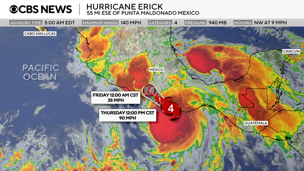
In the latest update, Erick was packing 140 mph winds with higher gusts, making it a Category 4 hurricane on the Saffir-Simpson wind scale. Those hurricane-force winds extend 25 miles from its center, with tropical storm-force winds extending up to 90 miles.
According to the NOAA's National Weather Service, hurricanes with this wind strength can cause "catastrophic damage," and can lead to power outages lasting weeks and possibly months.
 Hurricane Erick underwent rapid intensification on its path to Mexico and is forecast to hit the southern portion of the country as a Category 4 storm.
Nikki Nolan/CBS News
Hurricane Erick underwent rapid intensification on its path to Mexico and is forecast to hit the southern portion of the country as a Category 4 storm.
Nikki Nolan/CBS News
Erick transformed into a major hurricane, a Category 3, around 10 p.m. ET on Wednesday after undergoing rapid intensification, marking the first major storm of the East Pacific hurricane season.
The center of the storm was forecast to make landfall "in the western portion of the Mexican state of Oaxaca or the eastern portion of the Mexican state of Guerrero within the next few hours," the hurricane center said. It was then expected to "continue inland over southern Mexico."
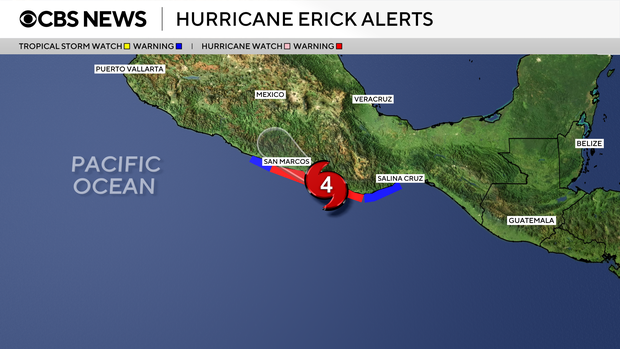
A hurricane warning is in effect for Acapulco to Puerto Angel and a watch has been issued from west of Acapulco to Tecpan de Galeana.
 Hurricane Erick is anticipated to impact Acapulco, Mexico — which was ravaged by Hurricane Otis in 2023 — as an "extremely dangerous" Category 4 storm on June 19.
Nikki Nolan/CBS News
Hurricane Erick is anticipated to impact Acapulco, Mexico — which was ravaged by Hurricane Otis in 2023 — as an "extremely dangerous" Category 4 storm on June 19.
Nikki Nolan/CBS News
Erick's categorization on the Saffir-Simpson scale only accounts for wind, and not the elements that tend to be the most deadly in cyclones.
"Water hazards — storm surge and inland flooding — have historically been the leading causes of loss of life during hurricanes," NOAA warns. "Hurricanes can also bring strong winds, tornadoes, rough surf, and rip currents."
Erick is forecast to produce between 8 to 12 inches of rain, with maximum totals of 16 inches across the states of Oaxaca and Guerrero, the National Hurricane Center said, leading to "life-threatening flooding and mudslides, especially in areas of steep terrain." Chiapas, Michoacan, Colima and Jalisco are expected to see between 2 and 4 inches of rain.
"Dangerous, life-threatening" storm surge, which is a rise in sea level during the storm, is also expected to create coastal flooding near and to the west of where the center of the storm hits land," the center said, and be accompanied by "large and destructive waves."
Erick is on track to impact Acapulco, an area that was devastated by Hurricane Otis in October 2023. Otis hit the city as a Category 5 and left dozens of people dead after its wind speeds increased by 115 mph in a single day — the second-fastest recorded rate in modern times, according to the National Hurricane Center.
"We are left with nothing," one woman said. "Everything is damaged."
More from CBS News
Li Cohen